LAANC is one of the success stories that have come out of the FAA’s Integration Office. LAANC (Low Altitude Authorization And Notification Capability) was prototyped in 2017, and since that time has become the universally accepted method of flying a drone in almost all controlled airspace. This is true, whether you’re flying under Part 107 or 49 USC 44809.
But it’s not everywhere. Especially for DOD Airspace.
And that brings us to the biggest shortcoming of LAANC: when we need to fly in Department of Defense (DOD) controlled airspace. And by this, I mean airspace associated with DOD airports, such as Air Force, Space Force, Naval Air Stations, etc. This article will not address flying on or over DOD property that is an official FAA No Fly Zone. There is much more needed than simply an article to accomplish that.
We’ve been told that DOD will eventually become part of the LAANC system, but we’ve seen no movement on that since the inception of LAANC. But there is an actual work around if you need to fly in DOD airspace. But it takes a little bit of forethought on your part. We at DSPA strongly suggest you apply for any and all DOD airspace you might ever think you may need to fly in at some point. It can likely save your bacon at some point.
Those in the business for a while will remember when we had to go to our Drone Zone Accounts, and apply for a 107.41 Airspace Authorization. It took time to fill these out. Especially if you are needing to apply for multiple airports. And it took time for those who approve them to check each one and approve or deny accordingly. It was a frustratingly slow process for all involved. That process still applies for DOD airspace. And it’s the accepted method for all DOD airspace sUAS flights.
But now it’s stupid fast, and relatively easy to get approval, if you know the right safety mitigations. And that is the crux of this article.
I recently had to renew my DOD 107.41 Airspace Authorizations for both Buckley Space Force Base (I’m still having a hard time not snickering when I write that, thanks to Steve Carell) and the Air Force Academy. And since we see this question a lot in the forums, I thought a short primer on applying for a DOD 107.41 was in order.
So how do we apply for (& more importantly get approved for) a DOD 107.41 Wide Area Airspace Authorization (COA).
Step One: Sign in to your Drone Zone Account. You can apply under either your Recreational Flyer dashboard or your Part 107 dashboard. The method for either are relatively the same.
Step Two: click “LAUNCH DRONE OWNERS AND PILOTS DASHBOARD”.

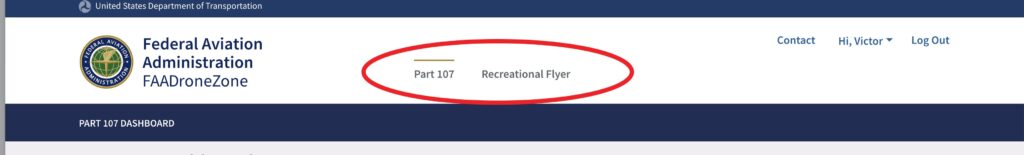
Step Three: Choose your “Part 107” or “Recreational Flyer” dashboard at the top of the page.
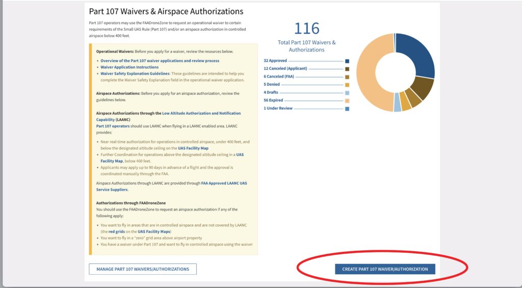
Step Four: For 107, click “CREATE PART 107 WAIVER/AUTHORIZATION”.
Step Five: Simply fill out the application. However, as with all government applications, “simply” is not an accurate modifier.
I’ll start with a 107 Application, and then below that I’ll point out the minor differences found in the Recreational Flyer dashboard.
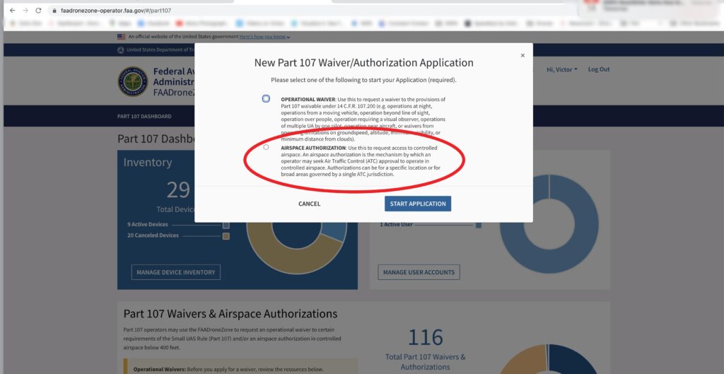
When you go to the next screen after creating your 107 application, you’ll want to check the “AIRSPACE AUTHORIZATION” option. That will take you to the start of the application. The other option is for Operational Waivers, and we won’t cover that here.
Give your application an appropriate name. I suggest the ICAO modifier. That also makes it easier to track if you need to go back and print it out after at a later date. For instance, my Air Force Academy COA is simply called “KAFF 107.41”. And that name is only for your reference. It will have no bearing on your application process.
Since you’re signed into your Drone Zone account, the rest of that page autofills with your info. So move on to the next page to get to the meat of your application.
Fill in the start and end dates. Make the start date about one or two weeks out. The person working on your application will change that as necessary. Also, for now you are only given the option of 12/31 of the following year as an end date option. For every for DOD COA I have received, and every one I know of from other people, the person approving the COA will extend those out usually for two years. I’ve even seen three years.
For “TIMEFRAME”, check all boxes. And for Frequency, check what you believe will be the frequency of your flights. Your answer will not impact the decision of the approval. Then choose the local time zone.
Under “PROPOSED LOCATION OF OPERATION”, simply mention that you’ll be flying in the airspace under control of “XXXX” airport as described in the UASFM associated with that airspace.
For “PROPOSED MAXIMUM FLIGHT ALTITUDE ABOVE GROUND LEVEL (AGL)” put 400’. That is the highest you’ll be flying.
Now some tricks…
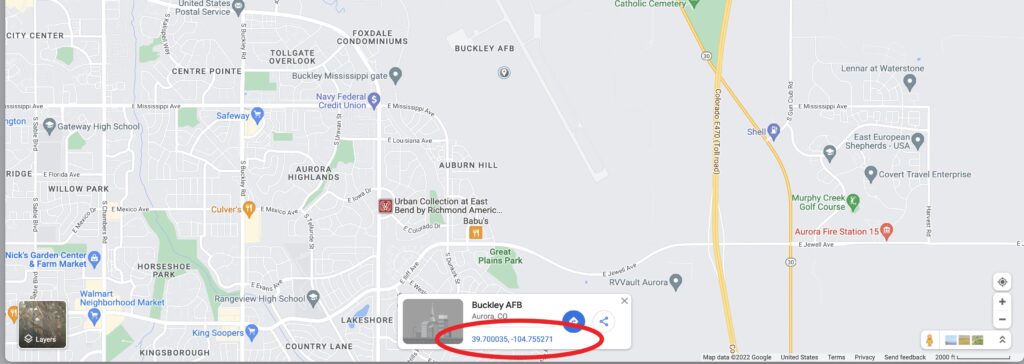
For the next few sections of the application, it’s best if you pull up Google Maps. Navigate Google Maps to the base you are applying for. Then drop a pin around the middle of the runways at that base. You’ll then end up with a digital GPS location at the bottom of that page. It’ll look something like “39.700035, -104.755271”, which is the GPS location for Buckley. Don’t worry about it being perfectly accurate. It’s just a reference point.
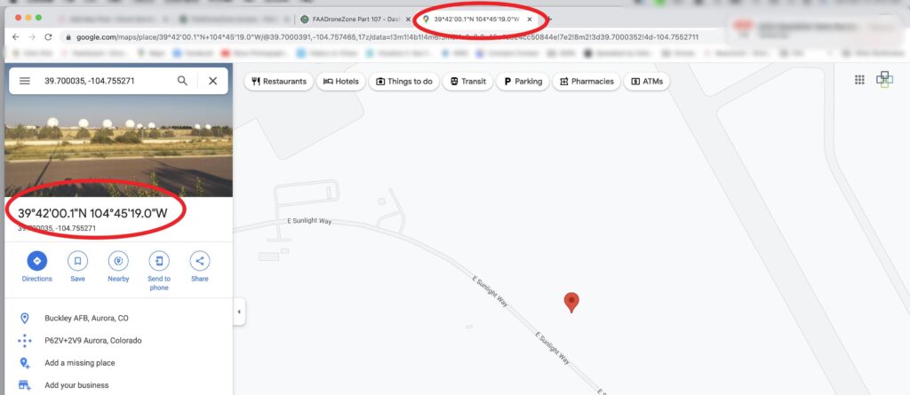
Click on that digital GPS link at the bottom of the page, and Google Maps automatically converts that digital number into the format you’ll need for the application. That format is “Degrees, Minutes, Seconds, and Direction”. Use those numbers to fill in the Longitude, Latitude, and Direction boxes. If you don’t have a whole number, just round up the number. Example, don’t put 42.3’, just put 43’. The application will not accept a decimal point in those boxes.
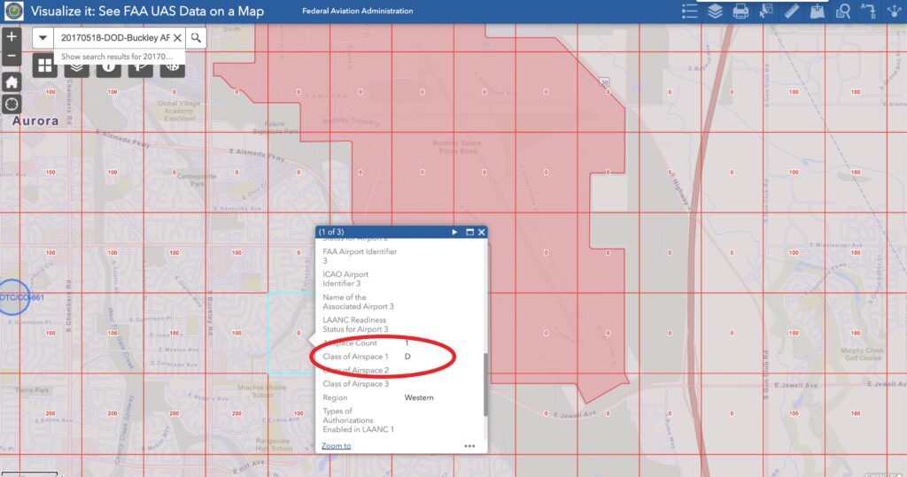
For Radius select “Blanket Area/Wide Area”. Nearest Airport will be the one you’re applying for. Use the ICAO Identifier. If you don’t know what that is, use the “Airport Identifier” link provided. And then select the Class of Airspace. If you don’t know that, use the “Visualize It” FAA UAS Map.
The next section, DESCRIPTION OF YOUR PROPOSED OPERATION” is the most important section, and that’s where the correct language is necessary. This is where you’ll include your safety mitigations. “I promise to fly safe”, or words to that effect, will not cut it. And yes, the FAA has received waiver and airspace authorization applications with words similar to that. Just don’t do it. This section will determine if you get an approval, or a denial. And “I promise to fly safe” will get you a denial. 100% of the time. 🙄
My best advice for you here is to make sure you write this out beforehand in a separate program like Word or Pages. If you take too long to write this while on Drone Zone, you will time out and have to start over. So write it out in a separate program, proofread it, edit accordingly, and then copy and paste your mitigations once you get to that point of your 107.41 application.
You need safety mitigations to include the following:
- RPIC will contact ATC if requested, and as described. This will be either before the flight (usually 1-24 hours prior, or both), and once flight is terminated. This was standard language for all DOD COAs for quite a while, but many DOD ATC are relaxing this requirement. So it may not be part of your approval. but do put it in your application. They’ll let you know if they require that. And some will require an email notification. For instance my new KBKF doesn’t require any notification, yet KAFF requires a minimum of an email 24 hours before flight. But they don’t require any notification post-flight.
- You’ll get a phone number to call if you have any questions about the COA or Airspace. Put that in your phone.
- Mention that you’ll check the current UASFM to ensure you’re complying with latest UASFM limits. And mention you will fly only to the limit of UASFM for all flights taken under approved COA. Also mention that you’ll check TFR.FAA.GOV to ensure there are no current TFRs in place.
- Next mitigation to mention is that you’ll ensure home point is set before launch, and that in the event of loss link, drone will be set to automatically return to home. And let them know that in the unlikely event (use the word “unlikely) of an uncontrolled flyaway, RPIC or VO will immediately call ATC and inform them of last know location, AGL, and direction of travel. Mention that RPIC will continue to attempt to control sUAS and/or follow it to maintain its location.
- Mention RPIC will maintain VLOS at all times. And remember that many DOD facilities have equipment such as Aerial Armor or DJI’s AeroScope, so they can tell when someone is in the air, as well as how far away they’re flying.
- Tell them that for any unforeseen obstacles or emergencies, or if instructed by ATC, RPIC will immediately terminate flight by returning to launch location or landing in a predetermined safe location as necessary.
- Mention weather minimums here as well. Many DOD COAs say something about no flights taking place if ceiling is less that 1000’ AGL (which is greater than our minimums, but its their airspace, so they can make that requirement), but you can just mention weather minimums under 107.41 if you want.
- And then, you can mention that RPIC is open to any additional safety mitigations suggested by ATC. Some people add “reasonable” in front of “safety mitigation” but I don’t suggest that.
Once you have that section filled out, the last thing you’ll do is the click the “No” box under “Relevant Existing Waivers”, then “NEXT”, then double check all your work on the next page. Click “Submit” if you’re satisfied with your application.
It’s that easy.
Most DOD COAs are taking less than a week from submission to approval. And you’ll be notified via email once you have your approval or denial. And if you followed these instructions, you should have an approval. If for some reason you got a denial, double check your safety mitigations and make sure you included everything in these instructions. There are still some Anti-Drone DOD ATC managers out there, but they’re getting fewer and fewer as time passes. And remember, it’s their final decision. And if you did receive a denial, you can always reach out to that ATC Manager and ask if there are any other safety mitigations they’d like to see in order to approve a Wide Area COA.
If you’re applying for an Airspace Authorization under your Recreational Flyer dashboard, you’ll follow the steps above, with two exception. First, the application page has only one option, choose “START APPLICATION”. Second, it asks if this is application is for a “Fixed Site”. Simply click “No”, then “Next”. On the following page you’ll also review and click “Submit”.
That’s it, you’re done. It takes some time, a bit of planning, and some writing, but having a DOD COA in your toolbox will get you work. And sometimes that work comes from other pilots who don’t haven’t taken the time to apply for a COA, but have a client needing immediate imagery from areas inside DOD airspace. You can come to their rescue and look good to your fellow local drone pilots.
We at DSPA hope this helps. And if it does, consider joining our membership, or even donating a bit. We would appreciate it. Funds raised by DSPA help cover travel expenses associated with various FAA functions and UAS seminars we go to in order to help keep the skies safe and open for UAS.
Kenji and Vic do not take any salary for what we do. We believe that a rising tide lifts all boats. And we both have boats in this water too. As do you. Thanks for your support!